Anticipation ran high as we all arrived on Friday night and arranged our groups for the flights the next day. The De Havilland Beaver we would be using to reach Lorna Lake is owned and operated by Tyax Air,
 and the owner/lead pilot would be riding with us the next day, thereby letting one of his other pilots do the grunt work. The plane will take the pilot, and four riders plus bikes. Our group of 12, therefore needed three flights. The first flight was at 0730hr and seeing as I was one of the responsible parties for breakfast on Sat morning I was up at 0545hr making sure that we were all fueled up for an epic adventure. With the first group out, and the breakfast dish's cleaned, we waited for our trip and eventually took off about 0945hr. The flight in is about 45 minutes in length and I have to say the father I flew out, the more I wondered if it was possible to get back to Tyaughten Lake by dark.
By the time we arrived at Lorna the wind had picked up, and the landing was a bit bumpy. Our pilot professionally put us down and with a little bit of muscle power we managed to hold the plane on the tiny dock as we unloaded the bikes.
 He was soon on his way back and we were left in the middle of the wilderness with a long day ahead.
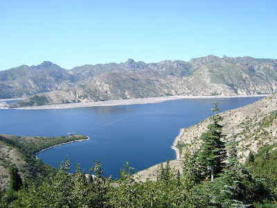
  Group 2 was waiting for us at the drop zone, and we quickly saddled up and headed off. Group 1 had already left for the top of Lorna pass and would be waiting for us there. The scenery was spectacular and after a short ride we started the first hike a bike up Lorna pass.

 A lot of the trail was rideable but with the slope being very loose and the trail quite steep, most of us decided to save a bit of energy for riding later and walked our bike up to the top.
Once at the top of Lorna Pass we met the other members of group 1 and headed off for the first of the days wicked downhills; this one about an hour in length. The trail was super flowy and fun. Once we reached the bottom we started our hike to the top of Deer pass. This climb was quite difficult and required a lot of hike a bike. We reached the summit in about an hour and forty five minutes and stopped for lunch.

It was now about 2 in the afternoon, and I really wondered whether we had bit off a bit too much to chew. The view from the top of Deer Pass included the Big Dog fire currently burning to the north.  Since the fire is in the middle of nowhere, there is no real attempt being made to put it out. There was not a cloud in the sky so that the smoke plume really stood out as it climbed skyward.
The climb up Deer Pass was really our last climb of the day and the rest of the day ripped by in a blur. We rode on for another 90 minutes and after stopping for a rest we asked “how much longer?’ Most of us thought hey maybe an hour. We were informed that we had about 3 to 3.5 hours of downhilling ahead of us before we reached Tyaughton Lake. Oh My God, maybe I had better have another goo.
The rest of the day was so sweet. Fast swoopy flowing single-track with the hammer on.
 Short rests to exclaim how much fun you were having and then another session to reinforce your thoughts.
By the time we finished back at the lake around 7 pm I was exhausted. It was apparent that everyone else was also as our feeble attempts at partying burned out at about 1030 and we all went to bed.
From my point of view, the riding I experienced on this ride may well have been the best I have had anywhere including our 13000 ft descent to the ocean in Peru this spring. If you get a chance, don’t pass a trip up to the Chilcotin's. The riding is topnotch.
 My first trip to the devastation caused by the volcano blowing its top on May 18,1980 was in 1985.
 on the south side of the mountain and riding up toward the
  Depending on the way you looked you could see any one of three other volcanoes; Mt Rainer, Mt Adams or Mt Hood. Although none of these have popped their top in the recent past, they are all considered a risk.
 The pitch eventually evened out and we were treated to some ripping single track until the trail deposited us into a washed out river bed.
 The trail truly disappeared and we were left maneuvering our way down the boulder strewn riverbed trying to find the trail on the other side. Thankfully, our Vancouver friends caught up with us as we entered the washout and we had 2 extra pairs of eyes on the lookout. Eventually after about an hour of slogging and/or pushing our bikes through the sandy riverbed we bush whacked into the trees and eventually found the trail out.


 before we started the long descent. On the way down, I hooked up with a couple of Austrians doing the out and back from the north side and we ripped the downhill passing cars through the switchbacks.
 If you think that your fitness is not up to snuff, do the climb heading in the southerly direction as the gradient is significantly less.


 After this ride, I can now see the attraction of road racing; what a natural high!

 The descent included probably the scariest moment so far in the race. About halfway down, while traveling at about 55km/hr we entered a totally unlit tunnel about 1 km long. As could be expected… you could see nothing. Not the walls, not the roof, not the road surface… Oh yeah, not any of the other 10 riders you entered the tunnel with. How there was not a major crash is beyond me…I personally just started yelling “Don’t hit me, don’t hit me, don’t hit me”, hoping that the sound of my voice would “encourage” others riders away from me. When I saw the “light” at the end of the tunnel, I have never accelerated so hard on bike in my life figuring that the sooner I was out, the safer I would be. Absolutely INSANE!
 “Supported” we headed down the other side for another crazy 45 km long train ride. On this descent I just decided to hide well back in the group and save my energy for the last big climb of the day.
  It turned out that this was good planning as again the “Mediterranean” heat started to take its toll on those that had expended a lot of energy pushing the head wind on the descent. In my group, people started popping off the back in droves as we started the slow climb up to Passo Mendola.
 Stelvio is extremely intimidating. The start seems to meander up the valley. At about 10 km in it starts switch backing seriously up the side of the mountain and at about 13 km in you look up and see the “wall”.
 The wall seems like an endless number of switchbacks and it literally goes straight up the side of the mountain. You can see it all from the bottom and it really does strike some serious “apprehension/fear” in your heart.
 Of course, as could be expected, the weather took a significant change for the worse at exactly this time with a nasty head wind and very cold rain when riding/looking toward the wall. Most of us had dumped our “warmer” clothes at the start as it seemed that the chance of rain/snow was extremely slim. We all paid the price now. Thankfully the switches facing away from the “wall” allowed us to warm up a bit before we bit back into it on the switch above. We eventually made it up to the highest point in the entire race (2750m) only to find a bunch of junior ski racers just finishing their morning training and coming off the snow loaded with skis. Slightly incongruous!
 As Dave and I started to descend toward the Passo d’Eira, the skies opened up and the lightning and thunder roared all around us. We both saw one lightning bolt hit a cell tower just off the side of the road and the thunder that followed just about knocked us off our bikes. The rain might as well have been biblical in amount. It just poured! Neither of us had real rain gear, and personally, I just made the decision to just get it over with as fast as I could. The descent off of Passo d’Eira was crazy. The road was a river with dirt and ditch debris sweeping over the road about 2 inches thick. I just thought mountain bike and let the thing go.
  By the time I reached the finish in Livigno, I could feel neither my fingers or my toes. It felt just like winter riding in Vancouver! The organizers at the finish were fantastic, attempting to deal with many hypothermic riders as they came across the finish.

 There were lots of road teams out for (I assume) recovery rides and the occasional hammer head blasting up the road. The descents were quick but not race fast as the various bikes and caliber of riders required a degree of conservatism.
 Blake and I stopped for lunch in Arabba, a town about half way through the ride and grabbed a sandwich to fuel our ascents of Passo Pordoi and Passo Sella.
 and celebrating Italian cycling along the route of numerous Giro I’talia’s makes it that much better.